Mobile Homes are permitted in a Residential Agricultural (RA) district and a Manufactured Home (R4) district. Any property currently being used for a mobile home is considered “grandfathered”. This means the property may continue to be used for a mobile home if the mobile home is not removed or destroyed.
Yes. In order to re-zone a piece of property, the owner of the property must complete the re-zoning application along with the associated fees. Once the application is completed, a public hearing and meeting date will be scheduled to go before the Planning Commission. The Planning Commission will follow the criteria written in the zoning ordinance to make a recommendation to City Council for final approval.
Please see the City of Semmes GIS Map. Click on the layers tab located in the top right-hand corner of the GIS map.
Yes. You are allowed to build an accessory building on your property as long as it meets the setback, lot coverage, height and square footage requirements. This requirement is to ensure that a piece of property is not completely covered and does not affect the drainage of the property.
Plan Development/Review:
Surveying and mapping services are provided primarily to other departments, but the public may obtain maps for a fee:
All petitions and paperwork are distributed through the City Clerk.
If you are not in the City limits and would like to fill out a petition to be annexed:
Jeffrey McKee
City Planner
Email:
[email protected]
Office Hours:
Monday – Friday
8:00 am to 4:00 pm
City Hall Address:
One Main Street
Semmes, AL 36575
Phone: (251) 649-5752
Fax: (251) 649-5788
These are the City approved regulations regarding subdividing property.
This is a checklist of all required documentation and submittals for a minor subdivision (6 lots or less) request.
This is a checklist of all required documentation and submittals for a major subdivision (7 lots or more).
This is an application with all required documentation and submittals for a commercial site plan.
Zoning is defined as laws that regulate the use of land within a municipality. The zoning ordinance controls the ways in which the land can be developed and what purposes the zoned land can serve. Zoning is what keeps a residential district residential, a commercial district commercial, and an industrial district industrial. Zoning is a means to preserve the value of property, and the safety and health of the community. It is intended to ensure, for example, that residents do not have to live next door to a loud, polluting factory that could potentially harm their health and lower their property value.
*Zoning layer default is hidden. The layer will need to be toggled on.
How does Zoning affect mobile homes?
Mobile homes are only allowed in a residential agriculture district.
Can I change the zoning district of my property?
The property owner can request to rezone his/her property. The request would have to go before the Planning Commission and City Council.
How do I know what my property is zoned?
Zoning Districts can be found on the GIS map. You can view the GIS map here, then selecting the zoning layer option in the top right-hand corner, or you may request a zoning verification.
Can I build a garage (or shed) on my zoned property?
Yes, but first need to reach out to Jeffrey McKee to make sure that all zoning regulations would be met.
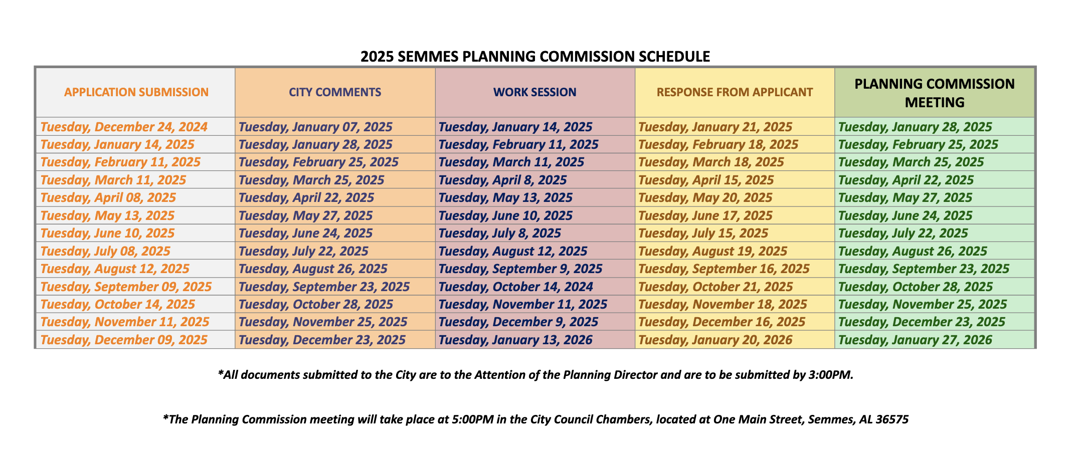
The Planning Commission will meet on the 2nd & 4th Tuesdays of each month – 5:00 PM (unless otherwise re-scheduled for a different time/date) – at City of Semmes Council Chambers @ One Main Street Semmes, AL 36575 (unless specifically posted otherwise). Special meetings can be called by the Chair – those meeting notices will be posted on the City’s website.
If you wish to speak during public comment, please download and fill this form out and return it to the clerk before the meeting starts.


Click or tap the image to access the interactive GIS City Map.

Click Here to review the map
Click or tap the image to access the Development Projects Map.

Click Here to review the map
Until the property is contiguous with current City limits, the property will be listed as “pending” status.
If contiguous, the City Planner will present potential annexation to the City Council who will vote to approve or deny the annexation petition.
Towncharts.com provides information and data about every geographic location in the United States, including cities, counties, and zip codes. This data is collected from a variety of sources to include the Decennial Census, Department of Labor, American Community Survey, Census Bureau International Database, CIA World Fact Book, and Center for Medicare and Medicaid Services (CMS), Bureau of Labor Statistics, Common Core of Data, Census Bureau Current Population Survey and the Organization for Economic Cooperation and Development. Click here for detailed City of Semmes Demographics.
For further questions regarding mapping, jurisdictions, annexations, or addressing, please contact the City Planner.
Phone: (251) 649-5752 Option #4
Fax: (251) 649-5788
Mailing Address:
P.O. Box 1757
Semmes, AL 36575
Hours:
Monday – Friday 7:30 am – 4:30 pm
City Hall Address | One Main Street, Semmes, AL 36575
Phone | (251) 649-8811
Fax | (251) 649-7711
Mailing Address | P.O. Box 1757, Semmes, AL 36575
Office Hours | Monday – Friday | 8:00 am – 5:00 pm
© 2025 City of Semmes, Alabama | All rights reserved | Privacy Policy | Accessibility Policy | Designed & Developed by Southern View Media.